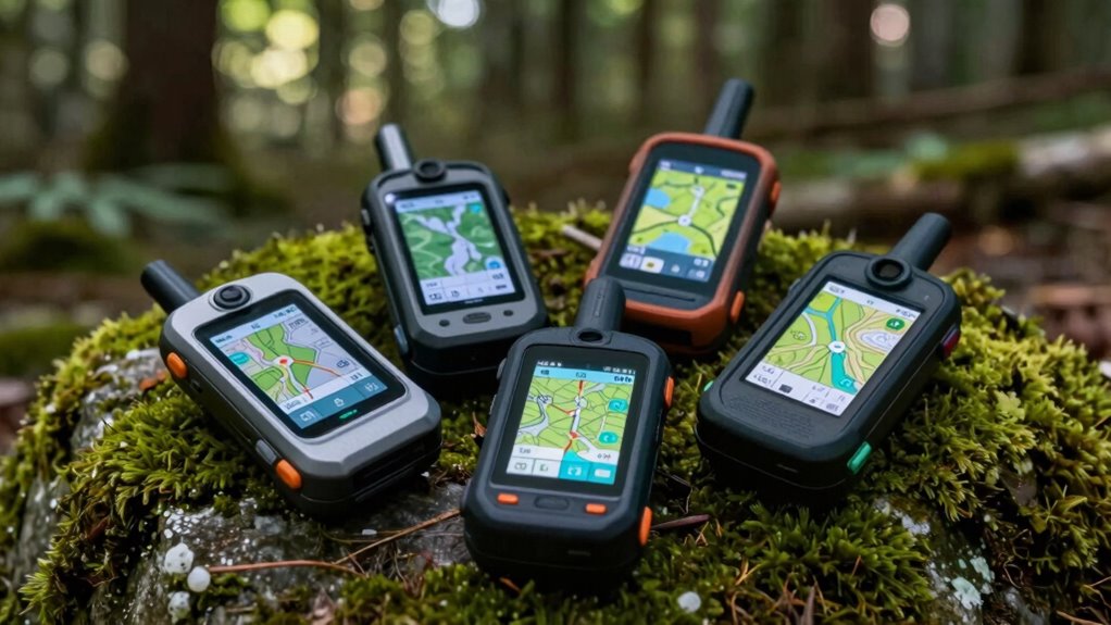

The best handheld GPS for off-grid navigation depends on whether you need detailed maps, long battery life, or a way to call for help beyond cell coverage. I rank the Garmin GPSMAP 67i as the best overall for pairing outdoor navigation with inReach satellite messaging, while the GPSMAP 65s is a strong choice for satellite reception and the eTrex 22x keeps mapping simpler. The main tradeoffs are screen size versus battery demands, advanced features versus ease of use, and navigation alone versus two-way communication. No GPS replaces a paper map, compass, or practiced skills. Read on for how the 14 options compare and which fit different kinds of trips.

Get school and study supplies delivered free — and shop member deals
- Fast, free delivery on millions of items
- Access to Prime Big Deal Days deals on October 6–7
- Prime Video, Amazon Music and more included
Key Takeaways
- Satellite messaging changes the job of a GPS. The GPSMAP 67i, Montana 700i, and GPSMAP H1i Plus pair navigation with satellite communication; the other models focus mainly on finding and recording routes.
- Screen size and packability pull in opposite directions. The Montana 700i favors a large touchscreen for viewing maps, while eTrex models are more compact choices for hikers who value a smaller device.
- Mapping detail separates capable route tools from basic trackers. The eTrex 10 is the simplest choice and has fewer mapping capabilities than models with color displays and preloaded maps.
- Special features come with practical tradeoffs. The Rino 750 adds two-way radio functions, while solar charging models depend on useful light and charging conditions rather than replacing battery planning.
- There are credible non-flagship alternatives. The GPSMAP 64sx and eTrex 32x offer established handheld navigation features, while the S190 and 3.2-inch USA topo-map options appeal to buyers comparing less familiar devices.
| Garmin Rino 750 Rugged Handheld Two-Way Radio and GPS Navigator |  | Best for Group Coordination | Radio: GMRS two-way radio | Communication: Voice and unit-to-unit text messaging | Claimed radio range: Up to 20 miles | VIEW ON AMAZON | See Our Full Breakdown |
| Garmin GPSMAP 65s Handheld GPS with Altimeter and Compass |  | Best for Challenging Satellite Conditions | Display: 2.6-inch sunlight-readable color display | Satellite support: Expanded global navigation satellite systems with multi-band technology | Maps: TopoActive routable maps and U.S. federal public land maps | VIEW ON AMAZON | See Our Full Breakdown |
| Garmin eTrex SE Handheld GPS Navigator |  | Best for Long Battery Runtime | Display: 2.2-inch high-resolution display | Battery: Two field-replaceable AA batteries; not included | Battery life: Up to 168 hours in standard mode; up to 1,800 hours in expedition mode | VIEW ON AMAZON | See Our Full Breakdown |
| Garmin GPSMAP H1 Rugged Handheld GPS Navigator with Touchscreen, Preloaded Maps, and Flashlight |  | Best Premium Rugged Navigator | Screen: 3.5-inch color touchscreen with scratch-resistant, sunlight-readable glass | Controls: Touchscreen, physical buttons, and customizable quick-action button | Preloaded maps: TopoActive maps for the U.S., Canada, and Mexico | VIEW ON AMAZON | See Our Full Breakdown |
| Garmin eTrex 32x Rugged Handheld GPS Navigator |  | Best for Compact On-Device Mapping | Display: 2.2-inch color TFT, 240 x 320 resolution | Maps: Preloaded TopoActive topographic maps with routable roads and trails | Satellite systems: GPS and GLONASS | VIEW ON AMAZON | See Our Full Breakdown |
| S190 Handheld GPS Navigator for Hiking |  | Best for Long Route Recording | Screen: 3.2-inch sunlight-readable color display | Satellite systems: GPS, BeiDou, Galileo, QZSS | Compass: 3-axis | VIEW ON AMAZON | See Our Full Breakdown |
| Garmin eTrex Solar Handheld GPS Navigator |  | Best for Solar-Extended Trips | Display: 2.2-inch LCD, 240 x 320 resolution | Navigation: Multi-band GPS | Battery life: Up to 200 hours without solar; unlimited in sunny conditions at 75,000 lux | VIEW ON AMAZON | See Our Full Breakdown |
| Garmin Montana 700i Rugged GPS Handheld with inReach Satellite Technology, 5-Inch Touchscreen (Renewed) |  | Best for Off-Grid Communication | Screen: 5-inch capacitive touchscreen | Display type: WVGA transflective, dual orientation | Navigation systems: GPS and Galileo | VIEW ON AMAZON | See Our Full Breakdown |
| Garmin eTrex 22x Rugged Handheld GPS Navigator |  | Best for Routable Trail Maps | Display: 2.2-inch sunlight-readable color screen | Resolution: 240 x 320 pixels | Preloaded maps: TopoActive maps with routable roads and trails | VIEW ON AMAZON | See Our Full Breakdown |
| Garmin eTrex 10 Worldwide Handheld GPS Navigator |  | Best for Basic, Button-Only Navigation | Display: 2.2-inch monochrome LCD | Resolution: 128 x 160 | Battery life: Up to 20 hours on two AA batteries | VIEW ON AMAZON | See Our Full Breakdown |
| Garmin GPSMAP 67i Rugged GPS Handheld with inReach Satellite Technology (Renewed) |  | Best for Extended Trips Beyond Cell Coverage | Display: 3-inch sunlight-readable color display | Satellite network: Iridium global satellite network | Navigation: Multi-band GNSS, sensors, preloaded TopoActive maps, and satellite imagery | VIEW ON AMAZON | See Our Full Breakdown |
| Garmin GPSMAP 64sx Handheld GPS |  | Best for Button-Controlled Simplicity | Model: 010-02258-10 | Display: 2.6-inch sunlight-readable color display | Maps: TopoActive maps for the U.S. and Australia | VIEW ON AMAZON | See Our Full Breakdown |
| Handheld GPS Navigator for Hiking with 3.2-Inch Screen and USA Topo Maps |  | Best Non-Garmin Option for Long Battery Life | Screen: 3.2-inch sunlight-readable LCD | Controls: Physical buttons | Satellite systems: GPS, Galileo, BeiDou, and QZSS | VIEW ON AMAZON | See Our Full Breakdown |
| Garmin GPSMAP H1i Plus Rugged Handheld GPS Navigator with inReach Plus Satellite Technology |  | Best Premium Satellite-Connected Navigator | Display: 3.5-inch sunlight-readable touchscreen | Maps: Preloaded North America TopoActive maps | Satellite communication: inReach Plus messaging, photo and voice sharing, tracking, and interactive SOS; active subscription required | VIEW ON AMAZON | See Our Full Breakdown |
| handheld gps for off grid navigation | Battery life | Display | Satellite systems | Maps |
|---|---|---|---|---|
| Garmin Rino 750 Rugged Handhel | Up to 14 hours with lithium-ion pack; up to 18 hours with optional AA batteries | 3-inch sunlight-readable touchscreen; landscape or portrait orientation | — | — |
| Garmin GPSMAP 65s Handheld GPS | — | 2.6-inch sunlight-readable color display | — | TopoActive routable maps and U.S. federal public land maps |
| Garmin eTrex SE Handheld GPS N | Up to 168 hours in standard mode; up to 1,800 hours in expedition mode | 2.2-inch high-resolution display | GPS, GLONASS, Galileo, BeiDou, and QZSS | — |
| Garmin GPSMAP H1 Rugged Handhe | Up to 145 hours in GPS mode; up to 840 hours in Expedition mode | — | Multi-band GPS and multi-GNSS | — |
| Garmin eTrex 32x Rugged Handhe | Up to 25 hours in GPS mode | 2.2-inch color TFT, 240 x 320 resolution | GPS and GLONASS | Preloaded TopoActive topographic maps with routable roads and trails |
| S190 Handheld GPS Navigator fo | Up to 36 hours | — | GPS, BeiDou, Galileo, QZSS | Preloaded USA topographic maps and worldwide basemap |
| Garmin eTrex Solar Handheld GP | Up to 200 hours without solar; unlimited in sunny conditions at 75,000 lux | 2.2-inch LCD, 240 x 320 resolution | — | — |
| Garmin Montana 700i Rugged GPS | — | — | — | Preloaded topographic and street maps |
| Garmin eTrex 22x Rugged Handhe | Up to 25 hours in GPS mode | 2.2-inch sunlight-readable color screen | GPS and GLONASS | — |
| Garmin eTrex 10 Worldwide Hand | Up to 20 hours on two AA batteries | 2.2-inch monochrome LCD | GPS, GLONASS, WAAS | — |
| Garmin GPSMAP 67i Rugged GPS H | Up to 165 hours in 10-minute tracking mode; up to 425 hours in expedition mode with 30-minute tracking intervals | 3-inch sunlight-readable color display | — | — |
| Garmin GPSMAP 64sx Handheld GP | Up to 16 hours in GPS mode | 2.6-inch sunlight-readable color display | GPS, GLONASS, and Galileo | TopoActive maps for the U.S. and Australia |
| Handheld GPS Navigator for Hik | Up to 36 hours | — | GPS, Galileo, BeiDou, and QZSS | Preloaded USA topographic maps |
| Garmin GPSMAP H1i Plus Rugged | Up to 145 hours in GPS mode; up to 840 hours in Expedition mode | 3.5-inch sunlight-readable touchscreen | — | Preloaded North America TopoActive maps |
More Details on Our Top Picks
Garmin Rino 750 Rugged Handheld Two-Way Radio and GPS Navigator
The Rino 750 suits off-grid trips where staying in touch with a nearby group matters as much as finding a route. Its GMRS radio combines voice and unit-to-unit text messaging with GPS and GLONASS positioning, while compatible Rino users can share their locations on the same channel. That makes it more useful for coordinating separated hikers or riders than the Garmin GPSMAP 65s, which prioritizes detailed mapping and multi-band positioning instead of built-in radio communication. The 3-inch sunlight-readable touchscreen is larger than the GPSMAP 65s display, and it can switch between portrait and landscape. The tradeoff is added reliance on compatible Rino devices for location sharing, plus a claimed radio range that can vary with terrain and conditions. Battery life reaches 14 hours with the included lithium-ion pack or up to 18 hours with optional AA batteries, which must be supplied separately.
Pros:- Combines GPS and GLONASS navigation with a GMRS two-way radio
- Voice, unit-to-unit text messaging, and location reporting support group coordination
- Sunlight-readable 3-inch touchscreen offers portrait and landscape views
- Can run on a lithium-ion pack or optional AA batteries
Cons:- Location reporting depends on other users having compatible Rino devices on the same channel
- Optional AA batteries are not included
- A two-way radio adds features and complexity that solo users may not need
Best for: Hiking, hunting, or riding groups who want handheld GPS navigation and direct GMRS voice communication in one device.
Not ideal for: Solo navigators who mainly need detailed maps and high-accuracy positioning; the built-in radio and compatible-device location sharing may add little value for them.
- Radio:GMRS two-way radio
- Communication:Voice and unit-to-unit text messaging
- Claimed radio range:Up to 20 miles
- Satellite reception:GPS and GLONASS
- Display:3-inch sunlight-readable touchscreen; landscape or portrait orientation
- Battery life:Up to 14 hours with lithium-ion pack; up to 18 hours with optional AA batteries
- Position reporting:Shows locations of compatible Rino users on the same channel
Our verdict“Choose the Rino 750 if your off-grid outings depend on radio contact and shared locations, rather than mapping alone.”
Garmin GPSMAP 65s Handheld GPS with Altimeter and Compass
For routes where terrain, tree cover, or built-up surroundings can make a position fix harder to trust, the GPSMAP 65s stands out for its multi-band GNSS support. It pairs that positioning capability with routable TopoActive maps, U.S. federal public land maps, a 3-axis compass, and a barometric altimeter. Compared with the Garmin eTrex 32x, it brings multi-band reception rather than relying on GPS and GLONASS, making it the stronger fit when positioning capability takes priority over a simple, compact setup. The tradeoff is a 2.6-inch screen that is smaller than the GPSMAP H1’s, and its public land map coverage is limited to the U.S. Garmin Explore compatibility also requires a compatible smartphone, so the phone remains part of trip planning and related app features. This is a mapping-focused choice, not a radio-equipped group communicator like the Rino 750.
Pros:- Multi-band GNSS support is suited to challenging reception conditions
- Includes routable TopoActive maps and U.S. federal public land maps
- Sunlight-readable color screen supports outdoor use
- 3-axis compass and barometric altimeter provide useful navigation data
Cons:- Garmin Explore compatibility requires a compatible smartphone
- Federal public land maps are limited to the U.S.
- The 2.6-inch screen is smaller than the GPSMAP H1 display
Best for: Backcountry hikers and land users who need routable maps, U.S. public land information, and multi-band positioning in areas with difficult reception.
Not ideal for: Buyers who want a large touchscreen, built-in group radio, or public land map coverage outside the United States.
- Display:2.6-inch sunlight-readable color display
- Satellite support:Expanded global navigation satellite systems with multi-band technology
- Maps:TopoActive routable maps and U.S. federal public land maps
- Navigation sensors:3-axis compass and barometric altimeter
- Compatibility:Garmin Explore website and app; compatible smartphone required
- Positioning:Multi-band GNSS support
Our verdict“Pick the GPSMAP 65s if difficult reception and U.S. public land mapping matter more than a larger screen or radio communication.”
Garmin eTrex SE Handheld GPS Navigator
The eTrex SE is the battery-first option in this group: two field-replaceable AA batteries support up to 168 hours in standard mode or up to 1,800 hours in expedition mode. That makes it a better match for long trips between charging opportunities than the Garmin eTrex 32x, which lists up to 25 hours in GPS mode. It also accepts GPS, GLONASS, Galileo, BeiDou, and QZSS signals, and its digital compass can show a heading while stationary. The smaller 2.2-inch display keeps the device compact, but it offers less screen space than the GPSMAP 65s or GPSMAP H1. Unlike those map-focused models, the supplied product details emphasize battery endurance and app-linked planning rather than preloaded routable maps. AA batteries are not included, and Garmin Explore features require a compatible smartphone.
Pros:- Long stated runtime, especially in expedition mode
- Runs on two field-replaceable AA batteries
- Supports GPS, GLONASS, Galileo, BeiDou, and QZSS
- Digital compass provides heading while stationary
Cons:- AA batteries are not included
- The 2.2-inch display gives less viewing space than the GPSMAP 65s and GPSMAP H1
- Garmin Explore app features require a compatible smartphone
Best for: Extended-trip hikers, emergency-kit owners, and travelers who want replaceable AA power and long runtimes without relying on frequent recharging.
Not ideal for: Buyers who want a large display or clearly specified preloaded routable maps; its compact screen and app-dependent trip tools may not suit them.
- Display:2.2-inch high-resolution display
- Battery:Two field-replaceable AA batteries; not included
- Battery life:Up to 168 hours in standard mode; up to 1,800 hours in expedition mode
- Satellite systems:GPS, GLONASS, Galileo, BeiDou, and QZSS
- Compass:Digital compass
- Water resistance:IPX7
- App compatibility:Garmin Explore app
Our verdict“Choose the eTrex SE when replaceable batteries and extended runtime outweigh a larger screen or a more map-forward feature set.”
Garmin GPSMAP H1 Rugged Handheld GPS Navigator with Touchscreen, Preloaded Maps, and Flashlight
The GPSMAP H1 is the most feature-rich choice here for buyers who want a large screen and rugged controls in one handheld. Its 3.5-inch sunlight-readable touchscreen works alongside physical buttons and a customizable quick-action button, giving it more screen area than the GPSMAP 65s while retaining tactile controls for rough-weather use. Multi-band GPS and multi-GNSS support pair with TopoActive maps for the U.S., Canada, and Mexico, plus an altimeter, barometer, and compass. Its stated runtime reaches 145 hours in GPS mode or 840 hours in Expedition mode, though those figures differ by operating mode. IP67 protection and MIL-STD 810 compliance add reassurance for demanding outings; a flashlight and siren add emergency utility. The tradeoffs are a feature-heavy format and the need to download high-resolution satellite imagery. LiveTrack also depends on a compatible smartphone and Wi-Fi or cellular service.
Pros:- Large 3.5-inch sunlight-readable touchscreen plus physical buttons
- Multi-band GPS and multi-GNSS support
- TopoActive maps cover the U.S., Canada, and Mexico
- IP67 rating, MIL-STD 810 compliance, flashlight, and siren
Cons:- High-resolution satellite imagery requires downloading
- LiveTrack requires a compatible smartphone and Wi-Fi or cellular service
- Its extensive controls and features may be more than minimalist users need
Best for: Backcountry users who want a large touchscreen, physical controls, broad North American topographic coverage, and a rugged build for extended trips.
Not ideal for: Minimalist hikers who prefer a small, simple handheld, or users who expect live tracking and satellite imagery to work without downloads or connectivity.
- Screen:3.5-inch color touchscreen with scratch-resistant, sunlight-readable glass
- Controls:Touchscreen, physical buttons, and customizable quick-action button
- Preloaded maps:TopoActive maps for the U.S., Canada, and Mexico
- Satellite systems:Multi-band GPS and multi-GNSS
- Sensors:Altimeter, barometer, and compass
- Battery life:Up to 145 hours in GPS mode; up to 840 hours in Expedition mode
- Water and dust resistance:IP67
- Durability and safety:MIL-STD 810; built-in LED flashlight and siren
- Connectivity:Wi-Fi; Garmin Explore app compatibility
Our verdict“Choose the GPSMAP H1 if you want a rugged, large-screen navigator with broad map coverage and long stated runtimes.”
Garmin eTrex 32x Rugged Handheld GPS Navigator
The eTrex 32x delivers a practical mix of preloaded routeable maps and navigation sensors in a compact handheld. Its TopoActive maps include routable roads and trails for hiking and cycling, so buyers can follow mapped routes without treating a phone as the primary screen. A 3-axis compass and barometric altimeter add orientation and elevation information; the eTrex SE also has a digital compass, but its supplied details do not list the same preloaded routable maps. The 32x uses GPS and GLONASS rather than the GPSMAP 65s’s multi-band GNSS, so it is less specialized for difficult reception conditions. Its 2.2-inch display keeps the unit small but makes map details harder to view than on the GPSMAP H1. Up to 25 hours in GPS mode and two AA batteries make spare-power planning straightforward, though batteries are not specified as included.
Pros:- Preloaded TopoActive maps include routable roads and trails
- 3-axis compass and barometric altimeter support off-grid orientation
- GPS and GLONASS satellite support
- 8 GB internal storage with a microSD card slot
Cons:- The 2.2-inch screen limits map detail visibility compared with larger models
- Uses two AA batteries and lists up to 25 hours in GPS mode
- GPS and GLONASS support is less specialized than the GPSMAP 65s multi-band positioning
Best for: Hikers and cyclists who want a compact device with preloaded routable topographic maps, a compass, and an altimeter.
Not ideal for: Users who need multi-band positioning, a larger map display, or exceptionally long stated runtimes between battery changes.
- Display:2.2-inch color TFT, 240 x 320 resolution
- Maps:Preloaded TopoActive topographic maps with routable roads and trails
- Satellite systems:GPS and GLONASS
- Sensors:3-axis compass and barometric altimeter
- Internal storage:8 GB
- Expandable storage:microSD card slot
- Battery life:Up to 25 hours in GPS mode
- Power:Two AA batteries
- Connectivity:ANT+
Our verdict“Pick the eTrex 32x if compact, preloaded trail mapping matters more than a large screen or multi-band reception.”
S190 Handheld GPS Navigator for Hiking
The S190 suits hikers who want a clear record of their route and a straightforward way to retrace it. Its 36-hour battery life and 64 GB of storage give it more room for extended outings and map files than the Garmin eTrex 22x, which runs on replaceable AA batteries and has 8 GB of internal memory. Four satellite systems—GPS, BeiDou, Galileo, and QZSS—add reception options, while the 3-axis compass can show direction when you are stopped. The sunlight-readable 3.2-inch color screen is also larger than the eTrex models’ 2.2-inch displays. The tradeoff is that the preloaded map detail may not hold up at close zoom levels without extra map downloads, and IP64 protection offers less water protection than the eTrex 22x’s stated rugged design. Choose it for route retracing and screen space, not as a set-and-forget detailed map library.
Pros:- Records routes and guides users back along the same path
- Four satellite systems provide multiple positioning options
- Sunlight-readable 3.2-inch color display and 3-axis compass
- 36-hour battery life and 64 GB of internal storage
Cons:- Preloaded map detail may be limited at close zoom without additional downloads
- IP64 protection is less water-resistant than IPX7-rated alternatives such as the Garmin eTrex 10
Best for: Hikers planning long day routes who want a larger color screen, route recording, and guidance back along their path.
Not ideal for: People who need detailed close-zoom maps straight out of the box or stronger stated water resistance for wet, exposed trips.
- Screen:3.2-inch sunlight-readable color display
- Satellite systems:GPS, BeiDou, Galileo, QZSS
- Compass:3-axis
- Maps:Preloaded USA topographic maps and worldwide basemap
- Internal memory:64 GB
- Battery life:Up to 36 hours
- Water resistance:IP64-rated
- Weight:7.84 ounces
Our verdict“Choose the S190 if route retracing, extended battery life, and a larger screen matter more than detailed preloaded maps or higher water resistance.”
Garmin eTrex Solar Handheld GPS Navigator
The Garmin eTrex Solar is the strongest fit here for hikers who can make use of regular sunlight and want to stretch time between charging stops. Garmin lists up to 200 hours without solar charging, with the possibility of unlimited battery life in sunny conditions at 75,000 lux. That is a different endurance strategy from the Garmin eTrex 22x, which uses two AA batteries and offers up to 25 hours; the 22x, however, comes with routable TopoActive maps, while the eTrex Solar has just 28 MB of listed storage. Multi-band GPS and a digital compass support position and heading, including while stationary. Its 2.2-inch screen is compact, so map viewing is less comfortable than on the S190 or Montana 700i. Solar charging also depends on exposure and conditions, making this a poor match for shaded routes or trips where reliable sunlight cannot be counted on.
Pros:- Up to 200 hours of battery life without solar charging
- Solar charging can extend runtime in strong sunlight
- Multi-band GPS and a digital compass
- IPX7 water resistance
Cons:- Solar charging depends on suitable sunlight and exposure
- The 2.2-inch display is small for inspecting maps
- Listed storage is only 28 MB, unlike the S190’s 64 GB
Best for: Backpackers and hikers on long, sunny routes who value extended runtime and a compact, button-controlled GPS.
Not ideal for: Users who spend most of their time under dense canopy, need a large map display, or want substantial onboard map storage.
- Display:2.2-inch LCD, 240 x 320 resolution
- Navigation:Multi-band GPS
- Battery life:Up to 200 hours without solar; unlimited in sunny conditions at 75,000 lux
- Water resistance:IPX7
- Connectivity:Bluetooth
- Storage:28 MB
- Controls:Buttons
- Model year:2023
Our verdict“Pick the eTrex Solar for sunny, extended trips where battery endurance matters more than screen size and onboard map capacity.”
Garmin Montana 700i Rugged GPS Handheld with inReach Satellite Technology, 5-Inch Touchscreen (Renewed)
For remote travel where being able to contact someone matters as much as finding a route, the Montana 700i stands apart from the navigation-only eTrex models. Its inReach two-way messaging and SOS add a communication option when cellular service is unavailable, but those satellite features require an active subscription. The 5-inch, dual-orientation touchscreen gives maps far more room than the Garmin eTrex Solar’s 2.2-inch display, and the glove-friendly design, 3-axis compass, and barometric altimeter support hands-on route use. Preloaded topographic and street maps also make it more map-focused than the Garmin eTrex 10’s worldwide basemap. The cost of that capability is bulk: at 1.5 pounds, it is much heavier than compact handhelds. This is also a renewed unit with a 90-day limited warranty, so buyers should weigh its condition and warranty against the advantages of communication and a large screen.
Pros:- inReach two-way messaging and SOS capability with an active subscription
- Large 5-inch glove-friendly touchscreen with dual orientation
- Preloaded topographic and street maps
- 3-axis compass, barometric altimeter, and multiple connectivity options
Cons:- Satellite messaging and SOS require an active subscription
- At 1.5 pounds, it is much heavier than the eTrex handhelds
- Renewed product includes only a 90-day limited warranty
Best for: Remote-area hikers and field users who want a large touchscreen plus satellite messaging and SOS capability with an active subscription.
Not ideal for: Minimalist backpackers who prioritize low weight, buyers who do not want a subscription, or anyone seeking a new unit with a longer warranty.
- Screen:5-inch capacitive touchscreen
- Display type:WVGA transflective, dual orientation
- Navigation systems:GPS and Galileo
- Maps:Preloaded topographic and street maps
- Satellite communication:inReach two-way messaging and SOS; active subscription required
- Sensors:3-axis compass and barometric altimeter
- Weight:1.5 pounds
- Warranty:90-day limited warranty
Our verdict“Choose the Montana 700i if satellite contact and a large map screen justify its weight, subscription requirement, and renewed status.”
Garmin eTrex 22x Rugged Handheld GPS Navigator
The Garmin eTrex 22x is a practical choice for hikers and cyclists who want trails and roads mapped on the device without stepping up to a large touchscreen. Its preloaded routable TopoActive maps give it a clearer out-of-box mapping advantage over the Garmin eTrex 10, whose worldwide basemap is more limited for detailed route planning. GPS and GLONASS support positioning, and the 2.2-inch sunlight-readable color screen keeps the display usable outdoors, though it leaves little room for studying a complicated junction. Battery life reaches up to 25 hours on two AA batteries, which makes field replacements straightforward but adds the need to carry spares. Compared with the S190, the eTrex 22x has less listed internal storage and a smaller screen, but its provided routable maps are a more defined starting point for trail and road navigation.
Pros:- Preloaded routable TopoActive maps for hiking and cycling
- Sunlight-readable 2.2-inch color display
- Supports GPS and GLONASS
- Uses two replaceable AA batteries and runs up to 25 hours
Cons:- Small screen limits map visibility at complex junctions
- AA batteries require carrying spares for longer trips
- Its 8 GB internal memory is less than the S190’s 64 GB
Best for: Hikers and cyclists who want preloaded routable trails and roads in a compact, button-operated GPS that uses replaceable AA batteries.
Not ideal for: Buyers who want a large display, extended runtime beyond 25 hours, or a rechargeable multi-GNSS device with more onboard storage.
- Display:2.2-inch sunlight-readable color screen
- Resolution:240 x 320 pixels
- Preloaded maps:TopoActive maps with routable roads and trails
- Satellite systems:GPS and GLONASS
- Internal memory:8 GB
- Memory expansion:MicroSD card slot
- Battery life:Up to 25 hours in GPS mode
- Batteries:2 AA
Our verdict“Choose the eTrex 22x for a compact GPS with routable maps ready to use, provided its small screen and AA-battery setup suit your trips.”
Garmin eTrex 10 Worldwide Handheld GPS Navigator
The Garmin eTrex 10 is the simplest and most map-limited option in this group, aimed at buyers who need a rugged position finder rather than a detailed screen map. Its monochrome 2.2-inch display and worldwide basemap can support basic orientation, while GPS, GLONASS, and WAAS provide several positioning aids. IPX7 water resistance and up to 20 hours on two AA batteries suit straightforward outdoor trips. By comparison, the Garmin eTrex 22x adds a color screen and preloaded routable TopoActive maps, making it easier to follow mapped trails; the eTrex 10’s 6 MB of storage is also a severe limit for added map detail. Paperless geocaching and elevation-point tracking broaden its uses, but neither compensates for the basic display when route detail is important. Choose it for uncomplicated waypoint and track duties, not map-rich off-grid planning.
Pros:- IPX7 water resistance for wet outdoor conditions
- GPS, GLONASS, and WAAS support
- Up to 20 hours of operation on two AA batteries
- Supports paperless geocaching and elevation-point tracking
Cons:- Monochrome screen offers less map detail than the eTrex 22x color display
- Only 6 MB of memory restricts additional map storage
- Worldwide basemap is less useful for detailed route planning than the eTrex 22x’s routable maps
Best for: Budget-conscious hikers and geocachers who mainly need position, waypoints, and basic track information in a waterproof, AA-powered unit.
Not ideal for: Trail users who need detailed topographic maps, color route guidance, or ample storage for downloaded map files.
- Display:2.2-inch monochrome LCD
- Resolution:128 x 160
- Battery life:Up to 20 hours on two AA batteries
- Satellite systems:GPS, GLONASS, WAAS
- Memory storage:6 MB
- Connectivity:USB
- Features:Paperless geocaching and elevation-point tracking
- Water resistance:IPX7
Our verdict“Choose the eTrex 10 for basic position and waypoint work, but pick the eTrex 22x if detailed trail maps are part of your off-grid plan.”
Garmin GPSMAP 67i Rugged GPS Handheld with inReach Satellite Technology (Renewed)
The GPSMAP 67i makes the strongest case here for remote trips where staying in touch matters as much as finding the route. Its multi-band GNSS, preloaded TopoActive maps, and satellite imagery support off-grid route planning, while the Iridium-based inReach features add two-way messages, tracking, and interactive SOS with an active subscription. Battery life reaches 425 hours in expedition mode, making it a better fit for long, low-frequency tracking than the GPSMAP 64sx, which is rated for up to 16 hours in GPS mode. The tradeoffs are meaningful: messaging and SOS depend on a paid subscription, and this unit is renewed, not described as new. Its 3-inch screen is also smaller than the H1i Plus display. I’d choose it for satellite safety and endurance rather than the biggest or newest interface.
Pros:- Two-way satellite messaging, location tracking, and interactive SOS are available with an active subscription.
- Multi-band GNSS and preloaded TopoActive maps support detailed off-grid navigation.
- Expedition mode offers up to 425 hours of battery life with 30-minute tracking intervals.
- Sunlight-readable color display is suited to outdoor use.
Cons:- Messaging, tracking, and SOS require an active subscription.
- Renewed condition may not suit buyers seeking a new device.
- The 3-inch display is smaller than the GPSMAP H1i Plus touchscreen.
Best for: Backpackers and field users taking multi-day trips beyond cell coverage who want satellite messaging and SOS alongside detailed navigation.
Not ideal for: Buyers who want satellite features without an ongoing subscription, prefer a new-condition device, or need a larger touchscreen.
- Display:3-inch sunlight-readable color display
- Satellite network:Iridium global satellite network
- Navigation:Multi-band GNSS, sensors, preloaded TopoActive maps, and satellite imagery
- Satellite features:Two-way messaging, location tracking, and interactive SOS; active subscription required
- Battery:Rechargeable lithium-ion
- Battery life:Up to 165 hours in 10-minute tracking mode; up to 425 hours in expedition mode with 30-minute tracking intervals
- Connectivity:Wi-Fi and compatible smartphone pairing
- Condition:Renewed
Our verdict“Choose the renewed GPSMAP 67i for long remote trips when satellite communication and extended expedition-mode battery life matter more than a large touchscreen.”
Garmin GPSMAP 64sx Handheld GPS
The GPSMAP 64sx is the straightforward choice for hikers who want physical controls and core outdoor instruments, not satellite messaging. Its 2.6-inch sunlight-readable screen, button operation, and 3-axis compass and barometric altimeter give it a practical, familiar setup for route work in gloves or wet conditions. It supports GPS, GLONASS, and Galileo, while preloaded TopoActive maps cover the U.S. and Australia. That map limit and its 16-hour GPS-mode battery life make it less suited to long, isolated journeys than the GPSMAP 67i or the 36-hour option from the other handheld in this batch. In exchange, it avoids subscription-dependent satellite safety features and keeps controls simple. I’d pick it for shorter, well-planned outings; buyers heading far off grid should favor longer endurance and broader communication options.
Pros:- Physical buttons are practical when wearing gloves or operating in wet conditions.
- GPS, GLONASS, and Galileo support satellite-based positioning.
- Includes a 3-axis compass and barometric altimeter.
- Preloaded TopoActive maps include routable roads and trails in the U.S. and Australia.
Cons:- Battery life is up to 16 hours in GPS mode, limiting use between charges on extended trips.
- Preloaded map coverage is limited to the U.S. and Australia.
- Does not offer the satellite messaging and SOS features found on the GPSMAP 67i and H1i Plus.
Best for: Hikers who prefer physical buttons and want a rugged GPS with compass and altimeter for day trips or shorter routes in the U.S. or Australia.
Not ideal for: Multi-day off-grid travelers who need long battery life, satellite messaging, or preloaded maps beyond the U.S. and Australia.
- Model:010-02258-10
- Display:2.6-inch sunlight-readable color display
- Maps:TopoActive maps for the U.S. and Australia
- Satellite systems:GPS, GLONASS, and Galileo
- Compass:3-axis compass
- Altimeter:Barometric altimeter
- Battery life:Up to 16 hours in GPS mode
- Design:Rugged and water-resistant
Our verdict“Pick the GPSMAP 64sx for button-based navigation and essential sensors on shorter outings, but choose a longer-running model for extended off-grid travel.”
Handheld GPS Navigator for Hiking with 3.2-Inch Screen and USA Topo Maps
This hiking GPS focuses on the basics that matter for offline route-finding: preloaded USA topographic maps, a sunlight-readable 3.2-inch screen, physical buttons, and a stated battery life of up to 36 hours. Its GPS, Galileo, BeiDou, and QZSS support gives it a broader listed satellite-system mix than the GPSMAP 64sx, and the included compass and barometric altimeter add useful orientation and elevation information when phone service is absent. Compared with the Garmin GPSMAP 67i, it trades away satellite messaging, SOS, and the listed satellite imagery for simpler operation without a subscription requirement in the supplied specifications. The IP66 rating is not described as full waterproofing, so I would not treat it as equivalent to a device with a stated waterproof rating. It suits buyers prioritizing battery life and core navigation over a mature satellite-safety ecosystem.
Pros:- Up to 36 hours of stated battery life supports longer outings between charges.
- Sunlight-readable 3.2-inch screen provides more viewing area than the GPSMAP 64sx.
- Supports GPS, Galileo, BeiDou, and QZSS.
- Includes USA topographic maps, a 3-axis compass, and a barometric altimeter.
Cons:- No satellite messaging or SOS capability is listed, unlike the GPSMAP 67i and H1i Plus.
- IP66 water resistance is not described as full waterproofing.
- Physical-button controls mean there is no touchscreen interface.
Best for: Hikers seeking a physical-button GPS with USA topo maps, onboard compass and altimeter, and longer stated battery life for routes away from phone service.
Not ideal for: Travelers who need satellite messaging or SOS, international preloaded maps, or a device explicitly specified as fully waterproof.
- Screen:3.2-inch sunlight-readable LCD
- Controls:Physical buttons
- Satellite systems:GPS, Galileo, BeiDou, and QZSS
- Position accuracy:Within 6 ft
- Maps:Preloaded USA topographic maps
- Compass and altimeter:3-axis compass and barometric altimeter
- Water resistance:IP66
- Battery life:Up to 36 hours
- Storage and charging:32 GB internal storage; USB-C charging
Our verdict“Choose this model if you want a larger screen, USA topo maps, and long stated battery life without prioritizing satellite communication.”
Garmin GPSMAP H1i Plus Rugged Handheld GPS Navigator with inReach Plus Satellite Technology
The GPSMAP H1i Plus is the most feature-rich pick in this group for buyers who want both hands-on controls and richer satellite communication. Its 3.5-inch touchscreen plus physical buttons offers more screen space than the GPSMAP 67i while retaining tactile controls, and its inReach Plus features add photo and voice sharing as well as messaging, tracking, and SOS with an active subscription. Preloaded North America TopoActive maps, multi-GNSS navigation, ABC sensors, a flashlight, and a siren make it a broad field tool rather than a bare GPS. It also lists up to 840 hours in Expedition mode, although the specified GPS-mode figure is 145 hours. The GPSMAP 67i remains a compelling alternative for buyers who need its satellite features in a renewed handheld, while the H1i Plus carries a subscription requirement and some map content is optional or downloadable.
Pros:- Touchscreen and physical buttons provide two ways to operate the device in changing field conditions.
- inReach Plus supports satellite messaging, photo and voice sharing, location tracking, and interactive SOS with an active subscription.
- Expedition mode is rated for up to 840 hours.
- Adds a flashlight and siren alongside multi-GNSS navigation and ABC sensors.
Cons:- Satellite communication and SOS require an active subscription.
- Some map content is downloadable or optional rather than included as preloaded content.
- Its expanded feature set may be more than needed for hikers seeking basic offline navigation.
Best for: Remote-area professionals and experienced hikers who want a large hybrid touchscreen-and-button interface plus expanded satellite sharing and SOS features.
Not ideal for: Buyers who want a simple, low-feature GPS, do not want an ongoing satellite subscription, or need every map layer preloaded without downloads.
- Display:3.5-inch sunlight-readable touchscreen
- Maps:Preloaded North America TopoActive maps
- Satellite communication:inReach Plus messaging, photo and voice sharing, tracking, and interactive SOS; active subscription required
- Navigation:Multi-band GPS and multi-GNSS
- Sensors:Barometer, compass, and altimeter
- Durability:Tested to MIL-STD 810 standards for water, shock, vibration, and extreme temperatures
- Battery life:Up to 145 hours in GPS mode; up to 840 hours in Expedition mode
- Safety features:LED flashlight and siren
- Mounting:Spine Mount 2 compatible; removable loop carabiner
Our verdict“Choose the H1i Plus for a large, rugged interface and expanded satellite communication; skip it if you only need basic GPS and maps.”

How We Picked
I compared the 14 listed devices around the demands of off-grid route finding: map usefulness, satellite positioning, controls that remain practical outdoors, power needs, rugged design, and options for communication when mobile coverage disappears. I also weighed the likely learning curve and the difference between a dedicated navigator and a device that adds features such as radio or satellite messaging. A large screen can make maps easier to read, but it can also mean a bulkier device and more power planning.
The order gives priority to how well each model supports independent travel, rather than to feature count alone. Devices that combine navigation with satellite messaging rank highly for remote trips where contacting others matters; capable mapping units follow for people who bring separate emergency communication or stay on familiar routes. Simpler eTrex models rank lower for feature depth but may be the better fit for buyers seeking a compact, straightforward navigator. I treat renewed models and less familiar brands with added caution: check included accessories, support, map coverage, and return terms before choosing.
Factors to Consider When Choosing Handheld Gps For Off Grid Navigation
Choosing an off-grid GPS is less about collecting features than matching the device to your route, backup plan, and comfort with outdoor electronics. These broader checks can help prevent a capable-looking unit from being the wrong tool for your trips.
Decide Whether You Need Satellite Communication
A GPS position on your screen does not send that position to anyone else. If you travel alone, visit remote areas, or need to check in with family, satellite messaging and SOS capability may justify choosing a communication-enabled model such as an inReach unit. Check the service requirements and message features before buying; a compatible device may require an active subscription and a clear view of the sky. If you mostly hike within reach of other people or carry a separate satellite communicator, paying for built-in messaging may add little value. Keep in mind that satellite messaging complements, rather than replaces, a route plan and emergency equipment. Decide on the communication plan before comparing screen sizes or extra tools.
Match the Map to the Terrain and Route
Map coverage matters more than the phrase “preloaded maps.” Check which regions and map types are included, whether the detail suits trails or roads, and how updates are handled. A simple track or waypoint display may be enough for following a known route, but it is less helpful when you need to identify trail junctions or choose a safe detour. Buyers sometimes assume every GPS comes with detailed maps for every destination; confirm coverage for the exact area you visit. For long trips, plan how you will add or update maps before leaving home. Carry a paper map for areas where electronic coverage or device access could fail.
Choose Controls You Can Use Outdoors
Touchscreens make panning and zooming maps feel familiar, while physical buttons can be easier to operate with gloves or wet hands. A larger screen may help with route decisions, but it takes more room in a pocket or pack and can increase the effort needed to keep the display powered. Small screens are compact, though they may require more zooming and menu work to inspect a complicated route. Consider whether you will wear gloves, use the unit in rain, or mount it on a bike or vehicle. If possible, compare the control layout and menu style before committing. Ease of use matters most when you need to make a quick decision outside.
Plan Power for the Whole Trip
Battery claims depend on settings, temperature, screen use, satellite messaging, and how often you record a track. Estimate your longest day away from a charger, then add reserve for delays rather than relying on a best-case figure. Check whether a model uses replaceable batteries, a rechargeable battery, or solar-assisted charging, and make sure that setup fits your trip. Solar support can help under favorable exposure but is not a substitute for a charged device or a backup power source. Cold weather can reduce practical battery performance, so keep spare power protected and close to your body when conditions call for it. A small power bank or spare batteries may matter more than a minor difference in listed runtime.
Treat Ruggedness as Part of a Backup System
Water and impact resistance reduce the chance that ordinary weather or a dropped device ends your route support, but no handheld GPS is indestructible. Check the product’s stated protection and operating limits rather than assuming that “rugged” covers every situation. Use a lanyard or secure mount to reduce loss, and protect the screen when the unit is packed with hard gear. Keep a compass, map, and the skill to use them; batteries, electronics, and GPS signals can all become unavailable. Renewed units call for extra checks on battery condition, included parts, and warranty coverage. Reliability comes from combining sound gear with a backup plan, not from one device alone.
Frequently Asked Questions
Is a handheld GPS with satellite messaging worth choosing over a navigation-only model?
It can be, if you travel beyond reliable cell coverage and want a way to send messages or request help from the device. The GPSMAP 67i, Montana 700i, and GPSMAP H1i Plus are the listed choices that pair navigation with inReach communication features. Check service and subscription requirements, since satellite messaging is not simply an offline map feature. If you already carry a separate satellite communicator, a navigation-only GPS may be the more sensible setup. Whichever you choose, learn how its emergency features work before a trip.
Can I use the eTrex 10 for backcountry trips if it does not offer the same mapping experience as the other models?
The eTrex 10 may suit a buyer who mainly needs basic position, waypoint, or track guidance and already has another reliable way to read terrain. It is less suited to someone who expects detailed on-device maps to help identify trails, junctions, or alternate routes. Before choosing it, check the map functions and included content against the areas you visit. Carry a paper map and compass, and practice matching your position to the terrain. If you rely on the device to make route decisions, a model with more mapping capability is a safer fit.
Should I choose a touchscreen GPS or one with physical buttons?
A touchscreen can make it easier to pan around a map and work through familiar phone-style menus, especially on a larger display. Physical controls can be simpler with gloves, in wet weather, or when you want to operate the unit without looking closely at the screen. The right choice depends on conditions and how much map interaction your trips involve, not on interface style alone. Also think about device size: a large touchscreen may be easier to read but less convenient to carry. If possible, try the controls before buying or review the manual to understand the menu flow.
Is a solar-assisted handheld GPS a good choice for a multiday trip?
Solar assistance can extend useful time between charges when the unit receives suitable light, but it should not be treated as guaranteed power. Shade, weather, how the device is carried, and screen use all affect how much benefit it provides. For a multiday route, plan around the GPS’s normal battery or charging method and bring a backup such as spare batteries or a power bank when compatible. Check whether the model’s solar feature supports your use pattern rather than assuming it can keep the unit charged continuously. Keep a paper map and compass available if the device runs out of power.
What should I check before buying a renewed handheld GPS?
Confirm what is included, especially the charging cable, mounts, or other accessories you need, and check the return and warranty terms. Ask about battery condition where that information is available, since battery capacity affects how practical the device is away from power. For a renewed inReach model, verify that the communication features can be activated under the current service requirements. Also check map coverage, software support, and whether the device is compatible with the equipment you already use. A renewed unit may fit your needs, but its condition and support matter as much as its feature list.
Conclusion
For the broadest mix of backcountry route guidance and satellite communication, I recommend the Garmin GPSMAP 67i as best overall. For buyers seeking strong GPS and mapping without built-in messaging, the GPSMAP 65s is a compelling alternative; the eTrex 22x is my best value direction for hikers who want color mapping in a simpler package. Beginners who want a straightforward, compact navigator can start with the eTrex SE, while buyers who prioritize a large map display should look at the Montana 700i. For specific needs, choose the Rino 750 for its two-way radio role, the eTrex Solar for solar-assisted charging, or the GPSMAP H1i Plus when its expanded inReach features match your communication plan. If you want basic navigation with minimal mapping, the eTrex 10 may suit you, but bring independent map and compass skills. Match the device to your route and power plan, then keep a non-electronic backup close.
Fall Picks
fall essentials
As an affiliate, we earn on qualifying purchases.





![Competitive Programmer's Handbook (2018) [Pdf]](https://fatsil.org/wp-content/uploads/2026/10/competitive-programmer-s-handbook-2018-pdf-featured-260x140.jpg)